Weather Alert in South Carolina
Rip Current Statement issued August 21 at 10:43AM EDT until August 21 at 8:00PM EDT by NWS Wilmington NC
AREAS AFFECTED: Coastal Horry; Coastal Georgetown
DESCRIPTION: * WHAT...For the High Surf Advisory, large breaking waves of 4 to 7 feet in the surf zone. For the High Rip Current Risk, dangerous rip currents. For the Coastal Flood Advisory, up to one half foot of inundation above ground level expected in low- lying areas near shorelines and tidal waterways. * WHERE...Coastal Horry and Coastal Georgetown Counties. * WHEN...For the High Surf Advisory, until 11 PM EDT this evening. For the High Rip Current Risk, until 8 PM EDT this evening. For the Coastal Flood Advisory, from 5 PM this afternoon to 9 PM EDT this evening. * IMPACTS...Vulnerable causeways to and from local beaches may experience minor coastal flooding. Low-lying roads and locations along the Intracoastal Waterway and adjacent tidal creeks may observe minor coastal flooding. Check with local officials for the latest information regarding coastal flood impacts and closures. Dangerous swimming and surfing conditions and localized beach erosion. Rip currents can sweep even the best swimmers away from shore into deeper water. * ADDITIONAL DETAILS...Affected areas listed are based on average tide conditions. Additional locations may experience flooding during periods of heavy rainfall, high winds, or other factors.
INSTRUCTION: If travel is required, allow extra time as some roads may be closed. Do not drive around barricades or through water of unknown depth. Take the necessary actions to protect flood-prone property. Inexperienced swimmers should remain out of the water due to dangerous surf conditions. Swim near a lifeguard. If caught in a rip current, relax and float. Don't swim against the current. If able, swim in a direction following the shoreline. If unable to escape, face the shore and call or wave for help.
Want more detail? Get the Complete 7 Day and Night Detailed Forecast!
Current U.S. National Radar--Current
The Current National Weather Radar is shown below with a UTC Time (subtract 5 hours from UTC to get Eastern Time).

National Weather Forecast--Current
The Current National Weather Forecast and National Weather Map are shown below.

National Weather Forecast for Tomorrow
Tomorrow National Weather Forecast and Tomorrow National Weather Map are show below.

North America Water Vapor (Moisture)
This map shows recent moisture content over North America. Bright and colored areas show high moisture (ie, clouds); brown indicates very little moisture present; black indicates no moisture.

Weather Topic: What is Condensation?
Home - Education - Precipitation - Condensation
 Next Topic: Contrails
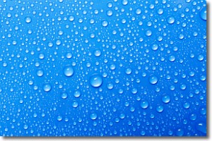
Condensation is the process which creates clouds, and therefore
it is a crucial process in the water cycle.
Condensation is the change of matter from a state of gas into a state of liquid,
and it happens because water molecules release heat into the atmosphere and
become organized into a more closely packed structure, what we might see as
water droplets.
Water is always present in the air around us as a vapor, but it's too small for
us to see. When water undergoes the process of condensation it becomes organized
into visible water droplets. You've probably seen condensation happen before on the
surface of a cold drink!
Next Topic: Contrails
Weather Topic: What are Cumulonimbus Clouds?
Home - Education - Cloud Types - Cumulonimbus Clouds
 Next Topic: Cumulus Clouds
The final form taken by a growing cumulus cloud is the
cumulonimbus cloud, which is very tall and dense.
The tower of a cumulonimbus cloud can soar 23 km into the atmosphere, although
most commonly they stop growing at an altitude of 6 km.
Even small cumulonimbus clouds appear very large in comparison to other cloud types.
They can signal the approach of stormy weather, such as thunderstorms or blizzards.
Next Topic: Cumulus Clouds
Current conditions powered by WeatherAPI.com


