Weather Alert in Virginia
Coastal Flood Advisory issued August 20 at 9:35PM EDT until August 21 at 5:00PM EDT by NWS Wakefield VA
AREAS AFFECTED: Richmond; New Kent; Eastern King William; Eastern King and Queen; Western Essex; Eastern Essex
DESCRIPTION: * WHAT...For the Coastal Flood Advisory, up to one foot of inundation above ground level expected in low-lying areas near shorelines and tidal waterways. For the Coastal Flood Watch, one to three feet of inundation above ground level possible in low- lying areas near shorelines and tidal waterways. * WHERE...Richmond, New Kent, Eastern King William, Eastern King and Queen, Western Essex and Eastern Essex Counties. * WHEN...For the Coastal Flood Advisory, until 5 PM EDT Thursday. For the Coastal Flood Watch, from Thursday afternoon through late Friday night. * IMPACTS...Numerous roads may be closed. Low lying property including homes, businesses, and some critical infrastructure may be inundated. Some shoreline erosion may occur.
INSTRUCTION: If travel is required, allow extra time as some roads may be closed. Do not drive around barricades or through water of unknown depth. Take the necessary actions to protect flood-prone property.
Want more detail? Get the Complete 7 Day and Night Detailed Forecast!
Current U.S. National Radar--Current
The Current National Weather Radar is shown below with a UTC Time (subtract 5 hours from UTC to get Eastern Time).

National Weather Forecast--Current
The Current National Weather Forecast and National Weather Map are shown below.

National Weather Forecast for Tomorrow
Tomorrow National Weather Forecast and Tomorrow National Weather Map are show below.

North America Water Vapor (Moisture)
This map shows recent moisture content over North America. Bright and colored areas show high moisture (ie, clouds); brown indicates very little moisture present; black indicates no moisture.

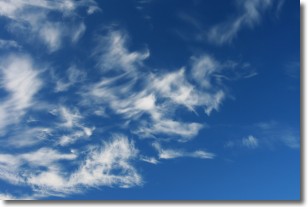
Weather Topic: What are Altostratus Clouds?
Home - Education - Cloud Types - Altostratus Clouds
 Next Topic: Cirrocumulus Clouds
Altostratus clouds form at mid to high-level altitudes
(between 2 and 7 km) and are created by a warm, stable air mass which causes
water vapor
to condense as it rise through the atmosphere. Usually altostratus clouds are
featureless sheets characterized by a uniform color.
In some cases, wind punching through the cloud formation may give it a waved
appearance, called altostratus undulatus. Altostratus clouds
are commonly seen with other cloud formations accompanying them.
Next Topic: Cirrocumulus Clouds
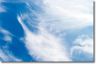
Weather Topic: What are Cirrostratus Clouds?
Home - Education - Cloud Types - Cirrostratus Clouds
 Next Topic: Cirrus Clouds
Cirrostratus clouds are high, thin clouds that form above
20,000 feet and are made mostly of ice crystals. They sometimes look like giant
feathers, horse tails, or curls of hair in the sky.
These clouds are pushed by the jet stream and can move at high speeds reaching
100 mph.
What do they indicate?
They indicate that a precipitation is likely within 24 hours.
Next Topic: Cirrus Clouds
Current conditions powered by WeatherAPI.com


