Weather Alert in South Carolina
Flood Warning issued August 13 at 10:43AM EDT by NWS Wilmington NC
AREAS AFFECTED: Horry, SC
DESCRIPTION: ...The Flood Warning continues for the following rivers in South Carolina...North Carolina... Waccamaw River At Conway affecting Horry County. Waccamaw River near Longs affecting Columbus, Brunswick and Horry Counties. ...The Flood Warning is cancelled for the following rivers in North Carolina... Waccamaw River near Freeland affecting Columbus and Brunswick Counties. * WHAT...Minor flooding is occurring and minor flooding is forecast. * WHERE...Waccamaw River at Conway. * WHEN...Until further notice. * IMPACTS...At 12.0 feet, Flooding will worsen in Lees Landing, Riverfront South, Pitch Landing, and Savannah Bluff. Flooding will also worsen along Waccamaw CIR, Riverside DR, and in low areas along Gray Oak DR. Flood waters will begin to affect Black Moss DR and Cypress Flat. Depot RD, New RD, and Jackson Bluff RD may begin to flood. The lowest homes on Riverside DR north of Conway may be affected. Witch Golf Course may begin to flood. Swamps will be heavily flooded. * ADDITIONAL DETAILS... - At 10:15 AM EDT Wednesday the stage was 11.2 feet. - Forecast...The river is expected to rise to 11.7 feet early Sunday morning. Additional rises are possible thereafter. - Flood stage is 11.0 feet. - weather.gov/safety/flood
INSTRUCTION: Motorists should not attempt to drive around barricades or drive cars through flooded areas. Caution is urged when walking near riverbanks. Additional information is available at water.noaa.gov/wfo/ilm . The next statement will be issued by this morning.
Want more detail? Get the Complete 7 Day and Night Detailed Forecast!
Current U.S. National Radar--Current
The Current National Weather Radar is shown below with a UTC Time (subtract 5 hours from UTC to get Eastern Time).

National Weather Forecast--Current
The Current National Weather Forecast and National Weather Map are shown below.

National Weather Forecast for Tomorrow
Tomorrow National Weather Forecast and Tomorrow National Weather Map are show below.

North America Water Vapor (Moisture)
This map shows recent moisture content over North America. Bright and colored areas show high moisture (ie, clouds); brown indicates very little moisture present; black indicates no moisture.

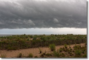
Weather Topic: What are Shelf Clouds?
Home - Education - Cloud Types - Shelf Clouds
 Next Topic: Sleet
A shelf cloud is similar to a wall cloud, but forms at the front
of a storm cloud, instead of at the rear, where wall clouds form.
A shelf cloud is caused by a series of events set into motion by the advancing
storm; first, cool air settles along the ground where precipitation has just fallen.
As the cool air is brought in, the warmer air is displaced, and rises above it,
because it is less dense. When the warmer air reaches the bottom of the storm cloud,
it begins to cool again, and the resulting condensation is a visible shelf cloud.
Next Topic: Sleet
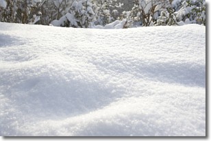
Weather Topic: What is Snow?
Home - Education - Precipitation - Snow
 Next Topic: Stratocumulus Clouds
Snow is precipitation taking the form of ice crystals. Each ice crystal, or snowflake,
has unique characteristics, but all of them grow in a hexagonal structure.
Snowfall can last for sustained periods of time and result in significant buildup
of snow on the ground.
On the earth's surface, snow starts out light and powdery, but as it begins to melt
it tends to become more granular, producing small bits of ice which have the consistency of
sand. After several cycles of melting and freezing, snow can become very dense
and ice-like, commonly known as snow pack.
Next Topic: Stratocumulus Clouds
Current conditions powered by WeatherAPI.com


