Weather Alert in Colorado
Red Flag Warning issued February 25 at 8:50AM MST until February 25 at 6:00PM MST by NWS Denver CO
AREAS AFFECTED: Larimer County Below 6000 Feet/Northwest Weld County; Boulder And Jefferson Counties Below 6000 Feet/West Broomfield County; North Douglas County Below 6000 Feet/Denver/West Adams and Arapahoe Counties/East Broomfield County; Northeast Weld County; Central and South Weld County; Morgan County; Central and East Adams and Arapahoe Counties; North and Northeast Elbert County Below 6000 Feet/North Lincoln County; Logan County; Washington County; Sedgwick County; Phillips County
DESCRIPTION: ...FIRE WEATHER WATCH REMAINS IN EFFECT FROM THURSDAY MORNING THROUGH THURSDAY AFTERNOON FOR WIND AND LOW RELATIVE HUMIDITY FOR MUCH OF THE PLAINS OF COLORADO... * AFFECTED AREA...Fire Weather Zones 238, 239, 240, 242, 243, 244, 245, 246, 248, 249, 250 and 251. * TIMING...For the Red Flag Warning, until 6 PM MST this evening. For the Fire Weather Watch, from Thursday morning through Thursday afternoon. * WINDS...Northwest 25 to 35 mph with gusts up to 55 mph today. On Thursday, northwest 15 to 25 mph with gusts to 40 mph. * RELATIVE HUMIDITY...As low as 15 percent. * IMPACTS...Conditions will be favorable for rapid fire spread. Avoid outdoor burning and any activity that may produce a spark and start a wildfire.
INSTRUCTION: A Red Flag Warning means that critical fire weather conditions are either occurring now....or will shortly. A combination of strong winds...low relative humidity...and warm temperatures can contribute to extreme fire behavior. A Fire Weather Watch means that critical fire weather conditions are forecast to occur. Listen for later forecasts and possible Red Flag Warnings.
Want more detail? Get the Complete 7 Day and Night Detailed Forecast!
Current U.S. National Radar--Current
The Current National Weather Radar is shown below with a UTC Time (subtract 5 hours from UTC to get Eastern Time).

National Weather Forecast--Current
The Current National Weather Forecast and National Weather Map are shown below.

National Weather Forecast for Tomorrow
Tomorrow National Weather Forecast and Tomorrow National Weather Map are show below.

North America Water Vapor (Moisture)
This map shows recent moisture content over North America. Bright and colored areas show high moisture (ie, clouds); brown indicates very little moisture present; black indicates no moisture.

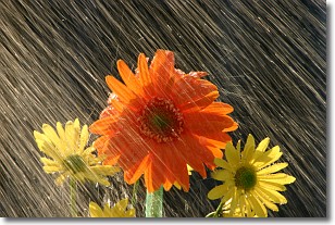
Weather Topic: What is Precipitation?
Home - Education - Precipitation - Precipitation
 Next Topic: Rain
Precipitation can refer to many different forms of water that
may fall from clouds. Precipitation occurs after a cloud has become saturated to
the point where its water particles are more dense than the air below the cloud.
In most cases, precipitation will reach the ground, but it is not uncommon for
precipitation to evaporate before it reaches the earth's surface.
When precipitation evaporates before it contacts the ground it is called Virga.
Graupel, hail, sleet, rain, drizzle, and snow are forms of precipitation, but fog
and mist are not considered precipitation because the water vapor which
constitutes them isn't dense enough to fall to the ground.
Next Topic: Rain
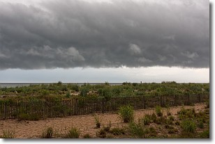
Weather Topic: What are Shelf Clouds?
Home - Education - Cloud Types - Shelf Clouds
 Next Topic: Sleet
A shelf cloud is similar to a wall cloud, but forms at the front
of a storm cloud, instead of at the rear, where wall clouds form.
A shelf cloud is caused by a series of events set into motion by the advancing
storm; first, cool air settles along the ground where precipitation has just fallen.
As the cool air is brought in, the warmer air is displaced, and rises above it,
because it is less dense. When the warmer air reaches the bottom of the storm cloud,
it begins to cool again, and the resulting condensation is a visible shelf cloud.
Next Topic: Sleet
Current conditions powered by WeatherAPI.com


