Weather Alert in Wyoming
Red Flag Warning issued August 14 at 1:03PM MDT until August 14 at 8:00PM MDT by NWS Riverton WY
AREAS AFFECTED: Yellowstone National Park; Absaroka Mountains/North Shoshone NF; East Wind River Mountains/South Shoshone NF; Salt and Wyoming Ranges/West Zone Bridger Teton NF; North Zone Bridger Teton NF and Grand Teton NP; West Wind River Mountains/East Zone Bridger Teton NF
DESCRIPTION: * IMPACTS: Low Humidities...Very Dry Fuels...Warm Temperatures... Strong Gusty Winds...Dry Thunderstorms and outflow winds...and Increasing Thunderstorm Activity could cause erratic fire behavior. * AFFECTED AREA: In Central WY Fire Zone....288. In Northwest WY Fire Zones...140...286...415. In West Central WY Fire Zones...414...416. * COUNTIES AFFECTED: In Central WY...Fremont. In North Central WY...Hot Springs...Park. In Northwest WY...Yellowstone National Park. In West Central WY...Lincoln...Sublette...Teton. * WIND: West 10 to 20 mph with gusts up to 30 mph. * THUNDERSTORMS: There is a 20 to 40 percent chance of thunderstorms, with gusty winds and frequent lightning being the main threats. * HUMIDITY: Higher elevations will see RHs around 20 percent, however lower valleys will see RHs around 15 percent. * TEMPERATURES: Highs in the mid 70s.
INSTRUCTION: A Red Flag Warning means that critical fire weather conditions are either occurring now....or will shortly. A combination of strong winds...low relative humidity...and warm temperatures can contribute to extreme fire behavior.
Want more detail? Get the Complete 7 Day and Night Detailed Forecast!
Current U.S. National Radar--Current
The Current National Weather Radar is shown below with a UTC Time (subtract 5 hours from UTC to get Eastern Time).

National Weather Forecast--Current
The Current National Weather Forecast and National Weather Map are shown below.

National Weather Forecast for Tomorrow
Tomorrow National Weather Forecast and Tomorrow National Weather Map are show below.

North America Water Vapor (Moisture)
This map shows recent moisture content over North America. Bright and colored areas show high moisture (ie, clouds); brown indicates very little moisture present; black indicates no moisture.

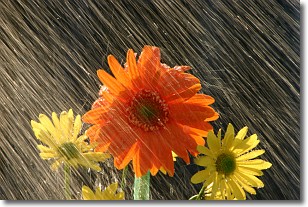
Weather Topic: What is Precipitation?
Home - Education - Precipitation - Precipitation
 Next Topic: Rain
Precipitation can refer to many different forms of water that
may fall from clouds. Precipitation occurs after a cloud has become saturated to
the point where its water particles are more dense than the air below the cloud.
In most cases, precipitation will reach the ground, but it is not uncommon for
precipitation to evaporate before it reaches the earth's surface.
When precipitation evaporates before it contacts the ground it is called Virga.
Graupel, hail, sleet, rain, drizzle, and snow are forms of precipitation, but fog
and mist are not considered precipitation because the water vapor which
constitutes them isn't dense enough to fall to the ground.
Next Topic: Rain
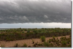
Weather Topic: What are Shelf Clouds?
Home - Education - Cloud Types - Shelf Clouds
 Next Topic: Sleet
A shelf cloud is similar to a wall cloud, but forms at the front
of a storm cloud, instead of at the rear, where wall clouds form.
A shelf cloud is caused by a series of events set into motion by the advancing
storm; first, cool air settles along the ground where precipitation has just fallen.
As the cool air is brought in, the warmer air is displaced, and rises above it,
because it is less dense. When the warmer air reaches the bottom of the storm cloud,
it begins to cool again, and the resulting condensation is a visible shelf cloud.
Next Topic: Sleet
Current conditions powered by WeatherAPI.com


