Weather Alerts for California
1. High Wind Warning for: Lassen-Eastern Plumas-Eastern Sierra Counties
2. High Wind Warning for: Mojave Desert Slopes
3. High Wind Warning for: Mono
4. Wind Advisory for: Central Siskiyou County
5. Wind Advisory for: Coastal Del Norte; Del Norte Interior
6. Wind Advisory for: Indian Wells Valley; Mojave Desert
7. Wind Advisory for: Modoc County
8. Wind Advisory for: Owens Valley; Death Valley National Park; Eastern Mojave Desert, Including the Mojave National Preserve
9. Wind Advisory for: San Bernardino County Mountains; Riverside County Mountains; San Diego County Mountains; Apple and Lucerne Valleys; Coachella Valley; San Diego County Deserts; San Gorgonio Pass Near Banning
10. Wind Advisory for: Surprise Valley California; Northern Washoe County
11. Wind Advisory for: Western Mojave Desert
12. Winter Weather Advisory for: Greater Lake Tahoe Area; Greater Lake Tahoe Area
13. Winter Weather Advisory for: Modoc County
14. Winter Weather Advisory for: Mono
15. Winter Weather Advisory for: Northern Trinity
16. Winter Weather Advisory for: West Slope Northern Sierra Nevada
17. Winter Weather Advisory for: Western Siskiyou County
18. Winter Weather Advisory for: Yosemite NP outside of the valley; Upper San Joaquin River
Want more detail? Get the Complete 7 Day and Night Detailed Forecast!
Current U.S. National Radar--Current
The Current National Weather Radar is shown below with a UTC Time (subtract 5 hours from UTC to get Eastern Time).

National Weather Forecast--Current
The Current National Weather Forecast and National Weather Map are shown below.

National Weather Forecast for Tomorrow
Tomorrow National Weather Forecast and Tomorrow National Weather Map are show below.

North America Water Vapor (Moisture)
This map shows recent moisture content over North America. Bright and colored areas show high moisture (ie, clouds); brown indicates very little moisture present; black indicates no moisture.

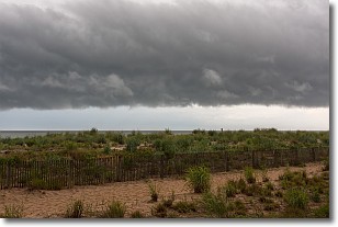
Weather Topic: What are Shelf Clouds?
Home - Education - Cloud Types - Shelf Clouds
 Next Topic: Sleet
A shelf cloud is similar to a wall cloud, but forms at the front
of a storm cloud, instead of at the rear, where wall clouds form.
A shelf cloud is caused by a series of events set into motion by the advancing
storm; first, cool air settles along the ground where precipitation has just fallen.
As the cool air is brought in, the warmer air is displaced, and rises above it,
because it is less dense. When the warmer air reaches the bottom of the storm cloud,
it begins to cool again, and the resulting condensation is a visible shelf cloud.
Next Topic: Sleet
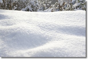
Weather Topic: What is Snow?
Home - Education - Precipitation - Snow
 Next Topic: Stratocumulus Clouds
Snow is precipitation taking the form of ice crystals. Each ice crystal, or snowflake,
has unique characteristics, but all of them grow in a hexagonal structure.
Snowfall can last for sustained periods of time and result in significant buildup
of snow on the ground.
On the earth's surface, snow starts out light and powdery, but as it begins to melt
it tends to become more granular, producing small bits of ice which have the consistency of
sand. After several cycles of melting and freezing, snow can become very dense
and ice-like, commonly known as snow pack.
Next Topic: Stratocumulus Clouds
Current conditions powered by WeatherAPI.com


