Weather Alerts for Idaho
1. Air Quality Alert for: Clearwater, ID; Idaho, ID
2. Air Quality Alert for: Latah, ID; Lewis, ID; Nez Perce, ID
3. Air Quality Alert for: Lewis, ID; Nez Perce, ID
4. Air Quality Alert for: Orofino/Grangeville Region
5. Air Quality Alert for: Teton, ID
6. Extreme Heat Warning for: Lewiston Area; Lower Garfield and Asotin Counties; Moses Lake Area; Upper Columbia Basin; Wenatchee Area; Okanogan Valley; Waterville Plateau; Central Chelan County
7. Flash Flood Watch for: West Central Mountains; Lower Treasure Valley; Boise Mountains; Upper Treasure Valley; Southwest Highlands; Western Magic Valley; Camas Prairie; Owyhee Mountains; Southern Twin Falls County; Upper Weiser River; Harney County; Baker County; Malheur County; Oregon Lower Treasure Valley
8. Flood Watch for: Idaho, ID; Lemhi, ID
9. Flood Watch for: Sawtooth/Stanley Basin
10. Flood Watch for: Shoshone/Lava Beds; Arco/Mud Lake Desert; Upper Snake River Plain; Lower Snake River Plain; Eastern Magic Valley; Southern Hills/Albion Mountains; Raft River Region; Marsh and Arbon Highlands; Franklin/Eastern Oneida Region; Bear River Range; Bear Lake Valley; Blackfoot Mountains; Caribou Range; Big Hole Mountains; Teton Valley; Centennial Mountains/Island Park; Beaverhead/Lemhi Highlands; Lost River Valleys; Lost River Range; Challis/Pahsimeroi Valleys; Frank Church Wilderness; Sun Valley Region; Big Lost Highlands/Copper Basin; Wood River Foothills
11. Heat Advisory for: Coeur d'Alene Area; Idaho Palouse; Lewis and Southern Nez Perce Counties; Northeast Blue Mountains; Washington Palouse; Spokane Area; Northeast Mountains; Okanogan Highlands; Western Okanogan County
12. Hydrologic Outlook for: Clearwater, ID; Deer Lodge, MT; Granite, MT; Mineral, MT; Missoula, MT; Powell, MT; Silver Bow, MT
Want more detail? Get the Complete 7 Day and Night Detailed Forecast!
Current U.S. National Radar--Current
The Current National Weather Radar is shown below with a UTC Time (subtract 5 hours from UTC to get Eastern Time).

National Weather Forecast--Current
The Current National Weather Forecast and National Weather Map are shown below.

National Weather Forecast for Tomorrow
Tomorrow National Weather Forecast and Tomorrow National Weather Map are show below.

North America Water Vapor (Moisture)
This map shows recent moisture content over North America. Bright and colored areas show high moisture (ie, clouds); brown indicates very little moisture present; black indicates no moisture.

Weather Topic: What is Condensation?
Home - Education - Precipitation - Condensation
 Next Topic: Contrails
Condensation is the process which creates clouds, and therefore
it is a crucial process in the water cycle.
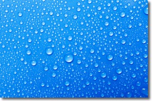
Condensation is the change of matter from a state of gas into a state of liquid,
and it happens because water molecules release heat into the atmosphere and
become organized into a more closely packed structure, what we might see as
water droplets.
Water is always present in the air around us as a vapor, but it's too small for
us to see. When water undergoes the process of condensation it becomes organized
into visible water droplets. You've probably seen condensation happen before on the
surface of a cold drink!
Next Topic: Contrails
Weather Topic: What are Cumulonimbus Clouds?
Home - Education - Cloud Types - Cumulonimbus Clouds
 Next Topic: Cumulus Clouds
The final form taken by a growing cumulus cloud is the
cumulonimbus cloud, which is very tall and dense.
The tower of a cumulonimbus cloud can soar 23 km into the atmosphere, although
most commonly they stop growing at an altitude of 6 km.
Even small cumulonimbus clouds appear very large in comparison to other cloud types.
They can signal the approach of stormy weather, such as thunderstorms or blizzards.
Next Topic: Cumulus Clouds
Current conditions powered by WeatherAPI.com


