Weather Alerts for Alaska
1. Flood Advisory for: Upper Kobuk Valleys
2. Flood Watch for: Kuskokwim Valley West; Kuskokwim Valley East; Northern Bristol Bay Coast; Inland Bristol Bay
3. Flood Watch for: Noatak Valley; Lower Koyukuk Valley; Upper Koyukuk Valley
4. Flood Watch for: South Slopes of the Western Brooks Range; Upper Kobuk Valleys
5. Flood Watch for: Southern Kenai Mtns
6. Flood Watch for: Western Susitna Valley; Southern Susitna Valley; Central Susitna Valley; Northern Susitna Valley
7. Heat Advisory for: Prince of Wales Island; Ketchikan Gateway Borough; City of Hyder; Annette Island
8. High Wind Warning for: Anchorage
9. High Wind Warning for: Anchorage Hillside / Eagle River
10. Hydrologic Outlook for: Anchorage; Anchorage Hillside / Eagle River; East Turnagain Arm; Portage; Lower Matanuska Valley; Hatcher Pass; Sutton / Upper Matanuska Valley; Eureka / Tahneta Pass; Southern Kachemak Bay; SW Kenai Peninsula; NW Kenai Peninsula; Skilak Lake; Southern Kenai Mtns; Interior Kenai Peninsula; Turnagain Pass; West Prince William Sound & Whittier; Tyonek; Valdez; Thompson Pass; Cordova; Western Susitna Valley; Southern Susitna Valley; Central Susitna Valley; Northern Susitna Valley
11. Hydrologic Outlook for: Anchorage; Anchorage Hillside / Eagle River; East Turnagain Arm; Portage; Lower Matanuska Valley; Hatcher Pass; Sutton / Upper Matanuska Valley; Eureka / Tahneta Pass; Southern Kachemak Bay; SW Kenai Peninsula; NW Kenai Peninsula; Skilak Lake; Southern Kenai Mtns; Interior Kenai Peninsula; Turnagain Pass; West Prince William Sound & Whittier; Tyonek; Valdez; Thompson Pass; Cordova; Western Susitna Valley; Southern Susitna Valley; Central Susitna Valley; Northern Susitna Valley
12. Hydrologic Outlook for: Kuskokwim Valley West; Kuskokwim Valley East; Interior Kuskokwim Delta; Western Capes; Northern Bristol Bay Coast; Inland Bristol Bay
13. Hydrologic Outlook for: South Slopes Of The Central Brooks Range; South Slopes of the Western Brooks Range; Noatak Valley; Lower Kobuk Valley; Upper Kobuk Valleys; Lower Koyukuk Valley; Upper Koyukuk Valley
14. Special Weather Statement for: Lower Matanuska Valley
15. Wind Advisory for: Delta Junction
16. Wind Advisory for: Eastern Alaska Range North of Trims Camp; Eastern Alaska Range South of Trims Camp
17. Winter Storm Warning for: Central Arctic Plains; Central Brooks Range
18. Winter Storm Warning for: Western Arctic Plains; Howard Pass and the Delong Mountains
19. Winter Weather Advisory for: Central Beaufort Sea Coast
Want more detail? Get the Complete 7 Day and Night Detailed Forecast!
Current U.S. National Radar--Current
The Current National Weather Radar is shown below with a UTC Time (subtract 5 hours from UTC to get Eastern Time).

National Weather Forecast--Current
The Current National Weather Forecast and National Weather Map are shown below.

National Weather Forecast for Tomorrow
Tomorrow National Weather Forecast and Tomorrow National Weather Map are show below.

North America Water Vapor (Moisture)
This map shows recent moisture content over North America. Bright and colored areas show high moisture (ie, clouds); brown indicates very little moisture present; black indicates no moisture.

Weather Topic: What is Freezing Rain?
Home - Education - Precipitation - Freezing Rain
 Next Topic: Graupel
Freezing rain is a condition where precipitation which has fallen in the form of
water droplets reaches temperatures which are below freezing and freezes upon
coming into contact
with surface objects. The result of this precipitation is a glaze of ice which
can be damaging to plants and man-made structures. A severe onset of freezing
rain which results in a very thick glaze of ice is known as an ice storm.
Next Topic: Graupel
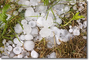
Weather Topic: What is Hail?
Home - Education - Precipitation - Hail
 Next Topic: Hole Punch Clouds
Hail is a form of precipitation which is recognized by large solid balls or
clumps of ice. Hail is created by thunderstorm clouds with strong updrafts of wind.
As the hailstones remain in the updraft, ice is deposited onto them until their
weight becomes heavy enough for them to fall to the earth's surface.
Hail storms can cause significant damage to crops, aircrafts, and man-made structures,
despite the fact that the duration is usually less than ten minutes.
Next Topic: Hole Punch Clouds
Current conditions powered by WeatherAPI.com


